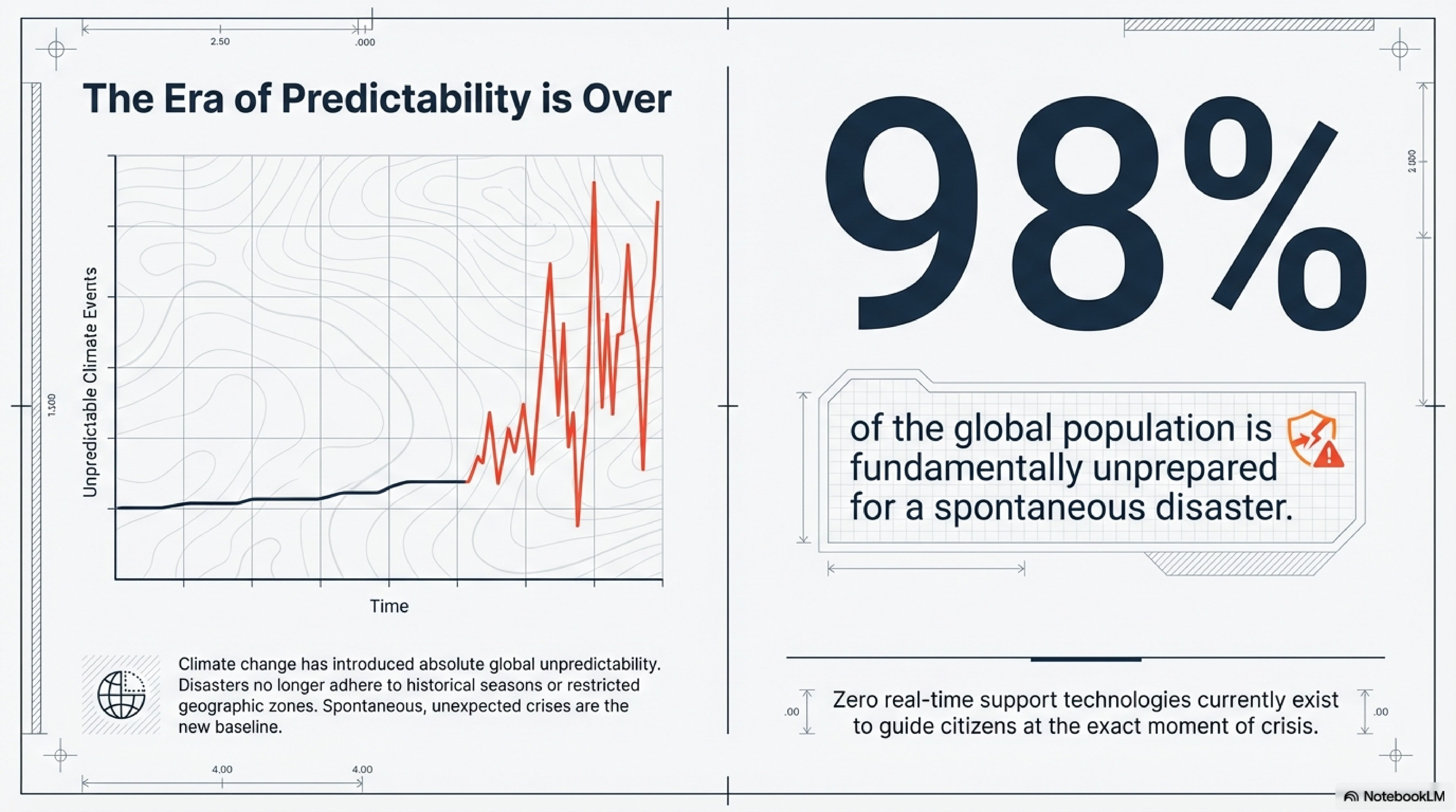
// CLIMATE RESILIENCE & NATIONAL SAFETY ASSET //

SAFE WAY: Topology-Aware Emergency Intelligence

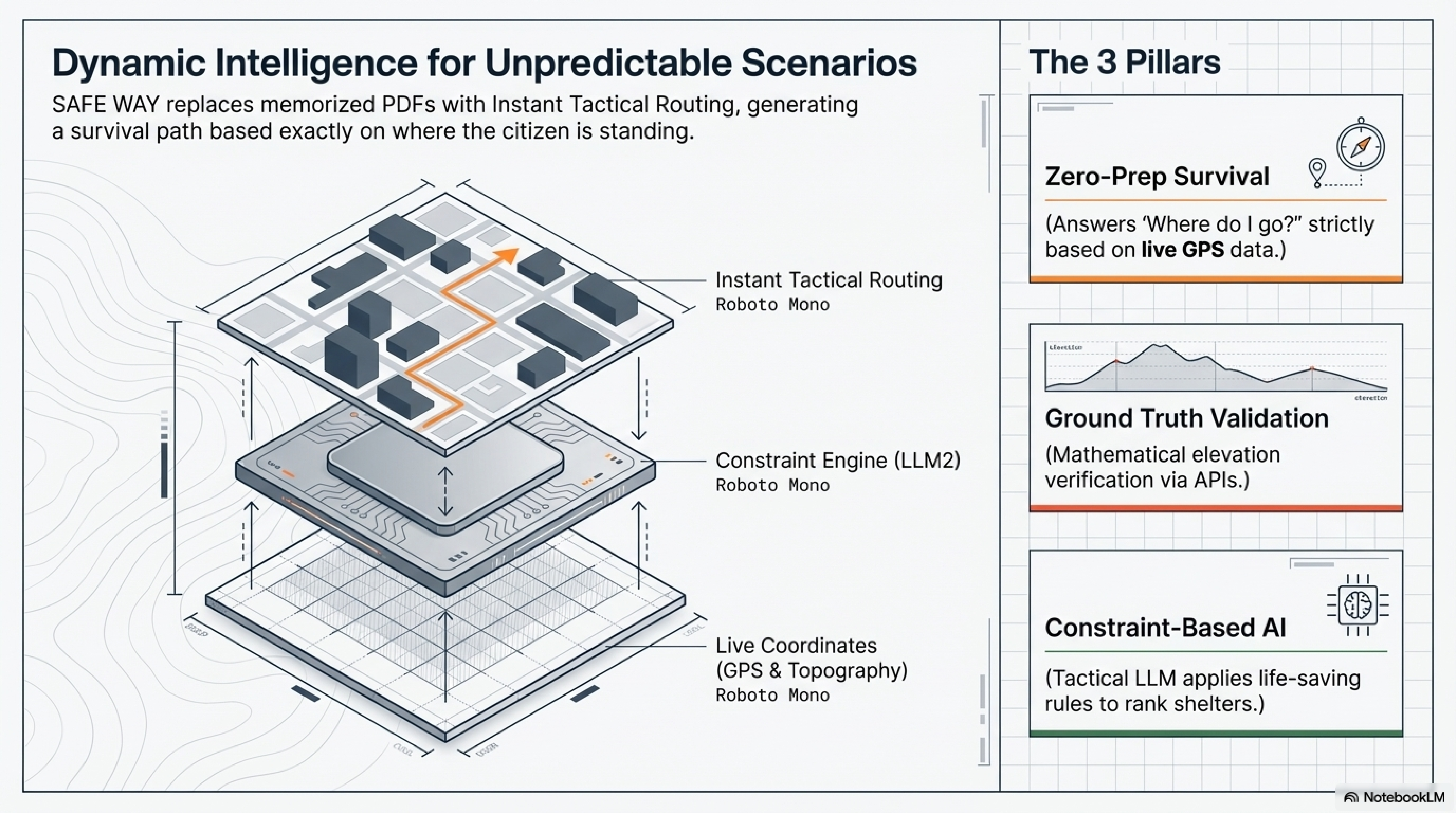
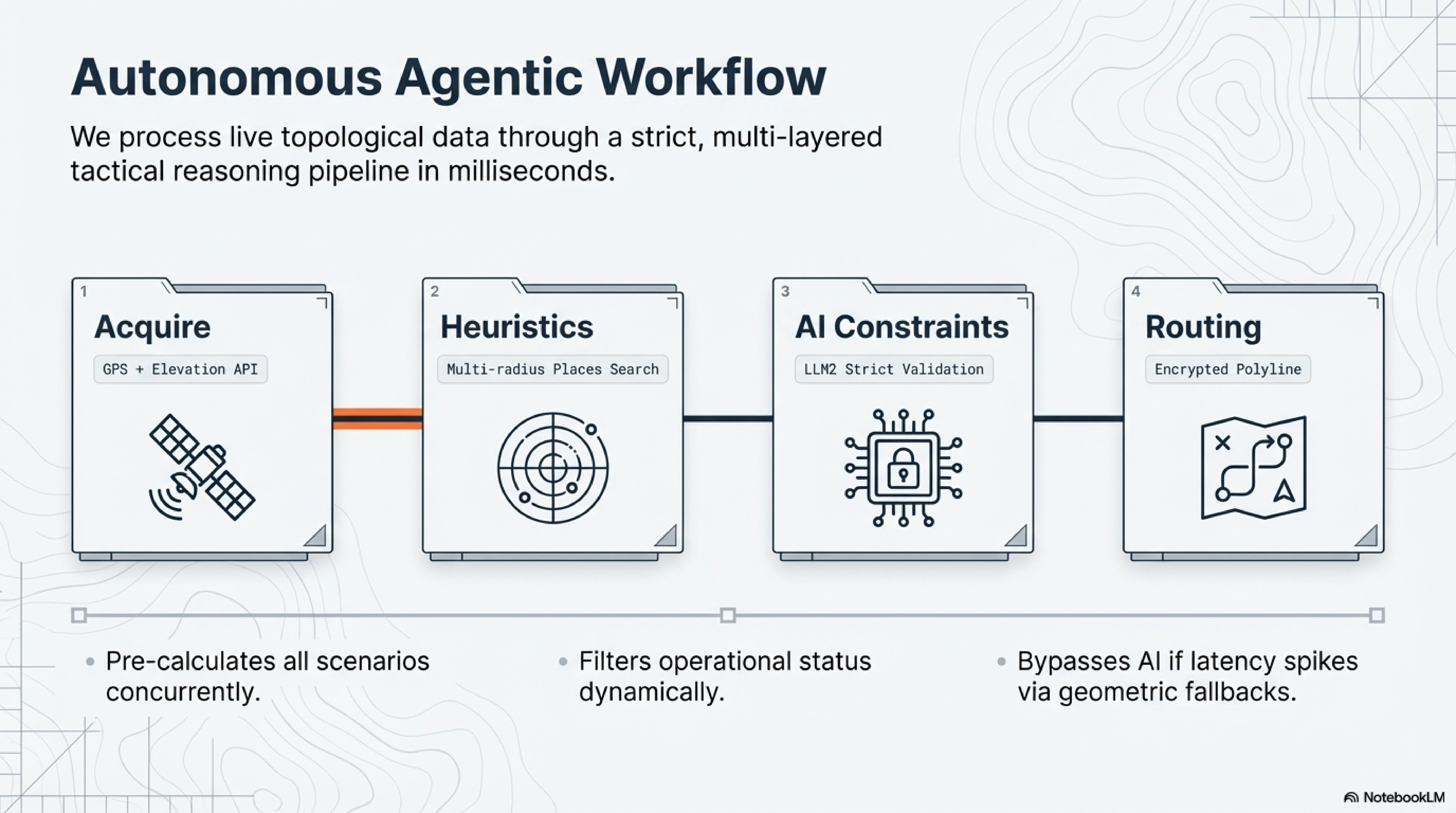
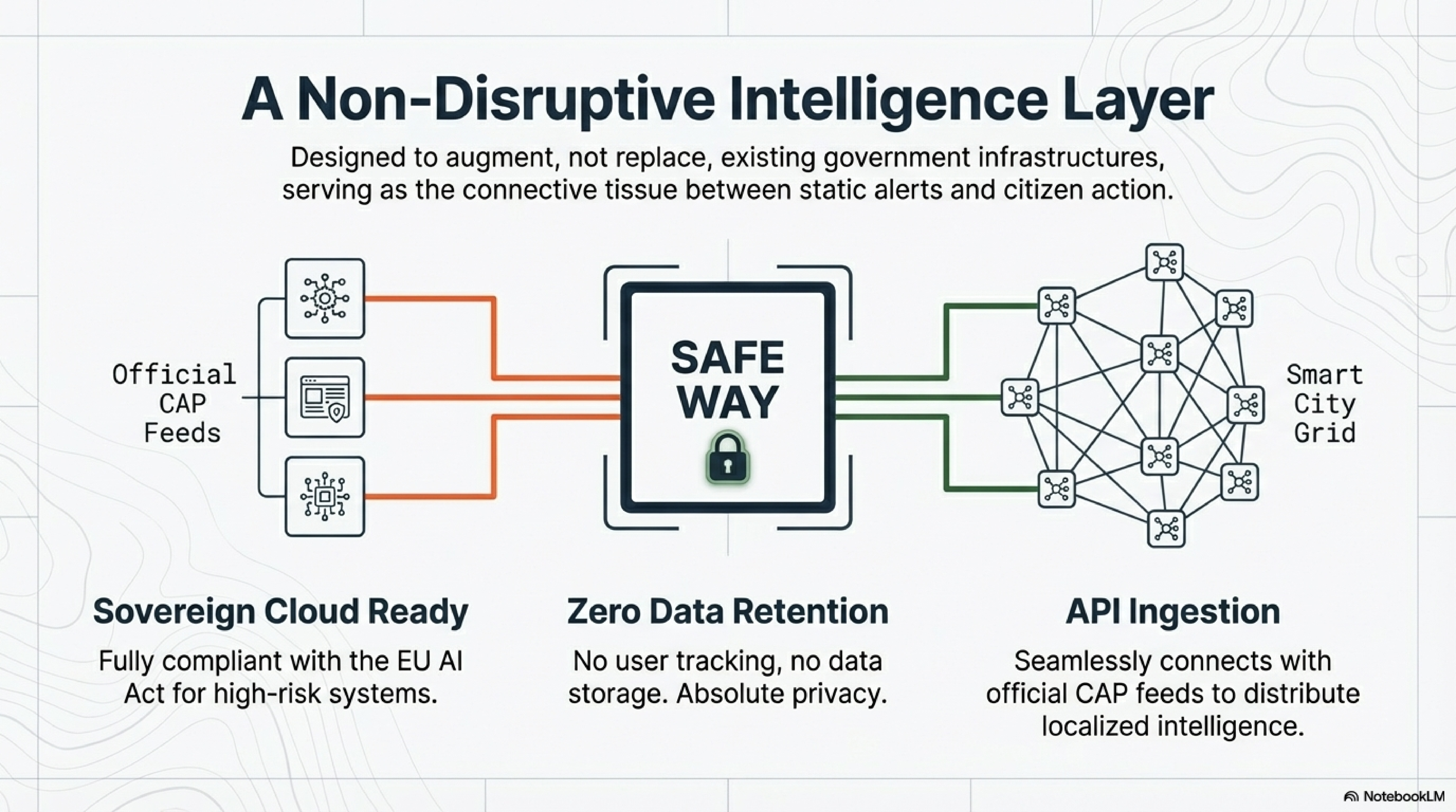
An agentic workflow infrastructure that transforms raw geospatial data into constraint-based, life-saving evacuation routes. We bring Decision Velocity to disaster management.

WATCH THE REAL APP IN ACTION
Google
AWS
Microsoft
Trusted by emergency agencies 
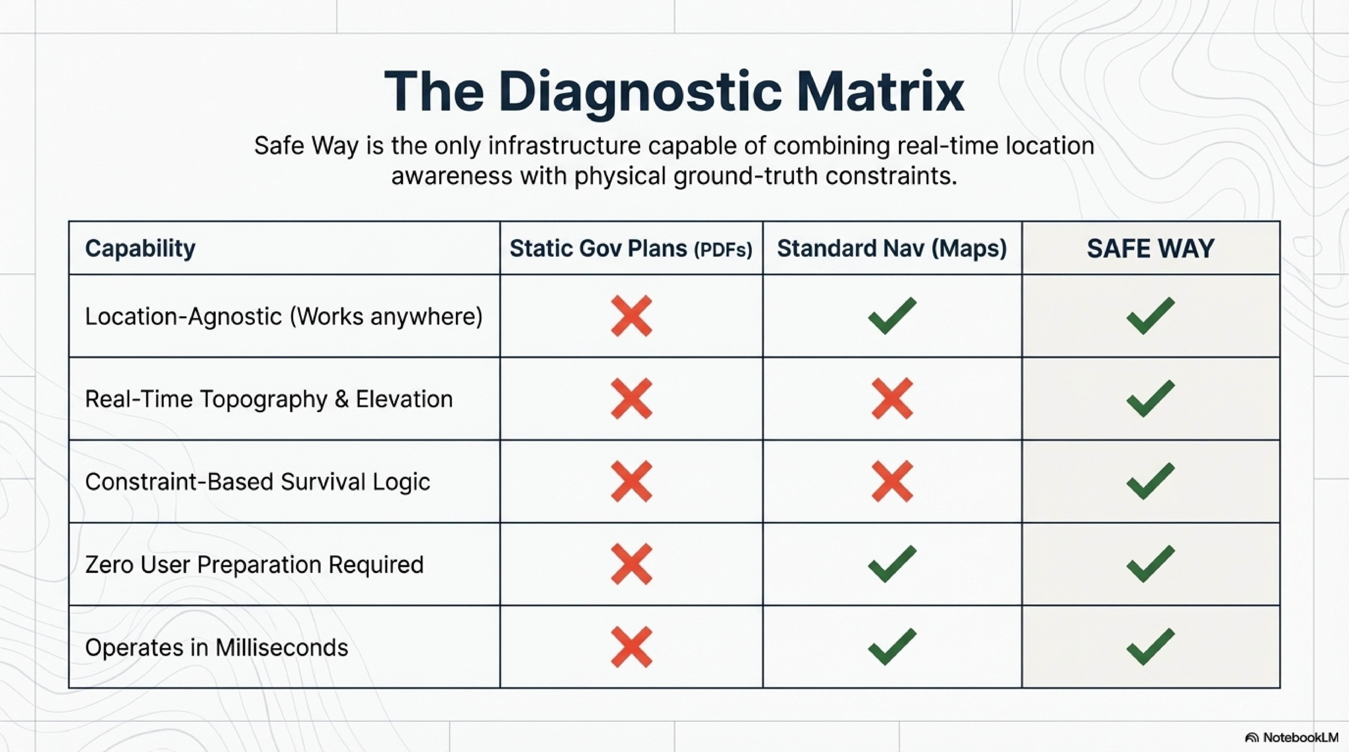
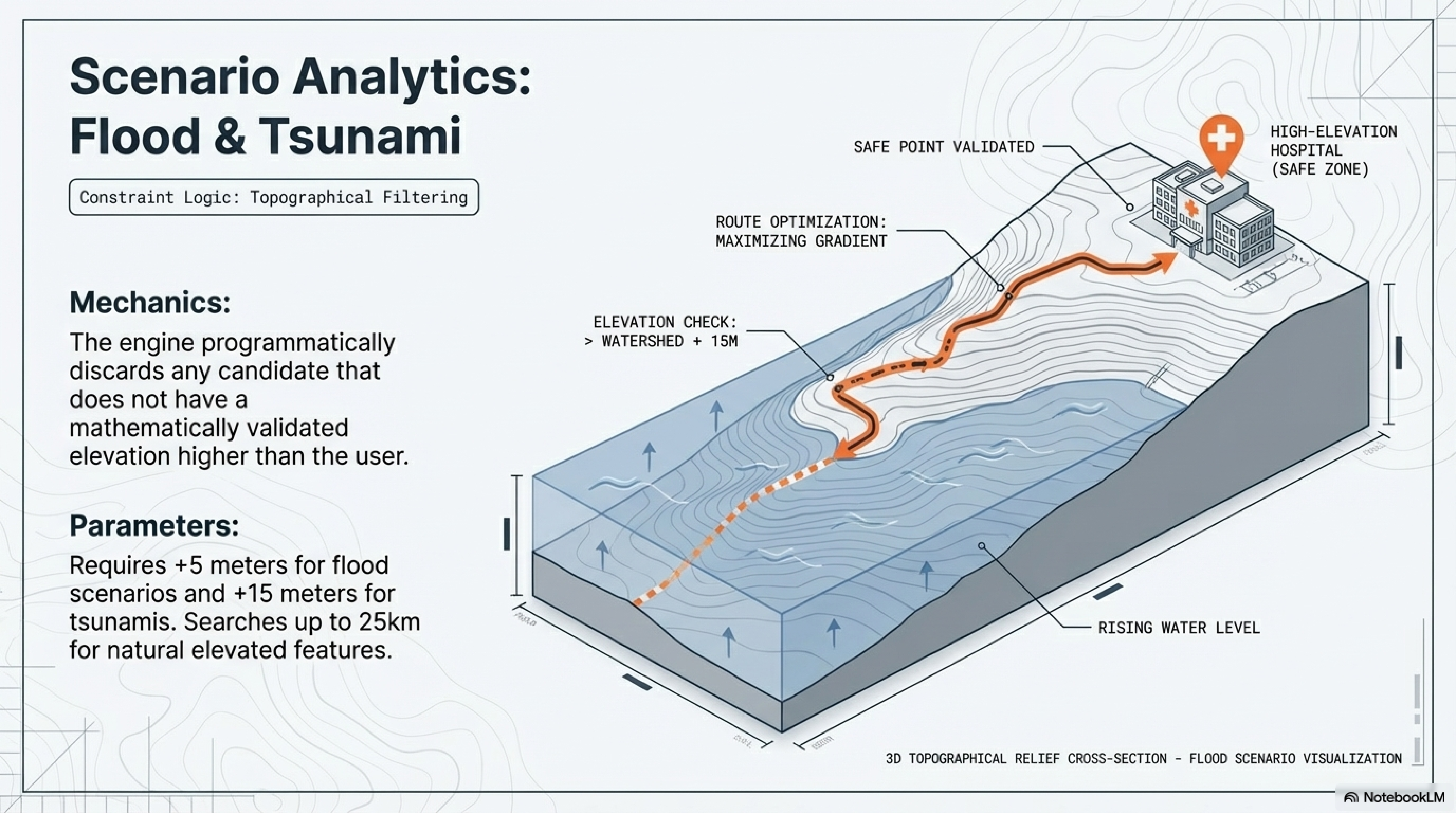
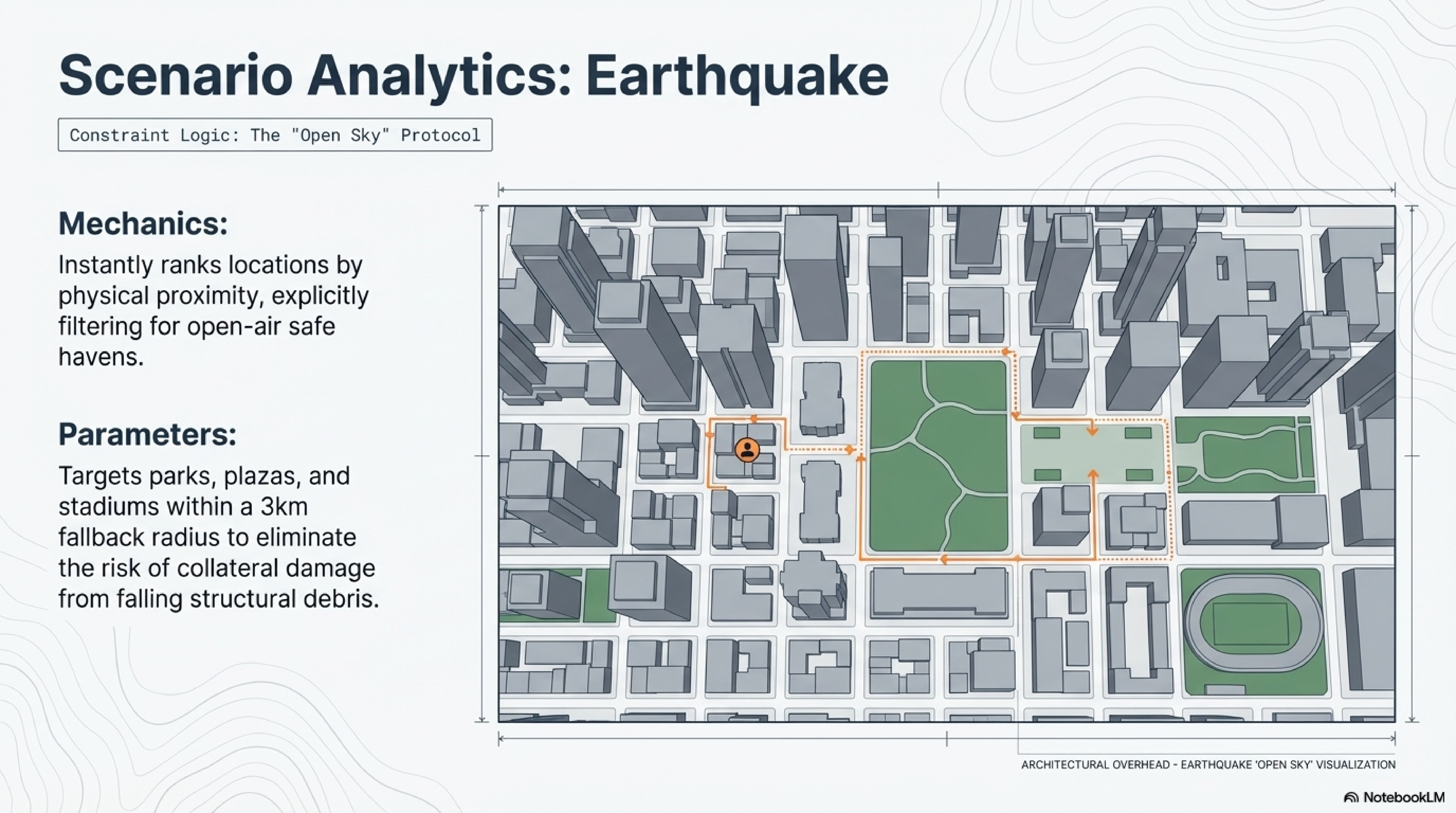
Building next-gen resilience infrastructure
Safe Way – isometric evacuation route map
Dynamic Intelligence – 3 Pillars: Zero-Prep, Ground Truth, Constraint AI
Autonomous Agentic Workflow – 4-step pipeline
// The Problem //

Standard navigation is traffic-centric. Disasters require topology-centric survival.

During a flood or tsunami, standard routing applications become a liability. They optimize for commute times and traffic avoidance, inadvertently guiding citizens into low-elevation zones, flooded underpasses, or collapsed infrastructure. They are completely blind to topological Ground Truth.

Standard Navigation is a Liability
⛰️

The Altitude Blind Spot

Standard apps guide people into flooded underpasses because they lack topology awareness. Routing engines ignore real-time elevation thresholds—deadly during floods.

Traffic-Centric Logic No Ground Truth
The Fatal Flaw of Static Evacuation Plans
⚠️

Information Paralysis

Without immediate, location-specific guidance, panic sets in within seconds. Citizens cannot process static PDF evacuation plans during crisis. Survival requires instant action.

Decision Paralysis PDF Overload
The Era of Predictability is Over – 98% of global population unprepared
AI

LLM Hallucinations

Standard AI chatbots give generic, unsafe advice without physical-world constraints.

Generic Advice, No Constraints.
// The Solution //

Autonomous Agentic Workflow for Operational Resilience

SAFE WAY does not just generate text; it executes a strict, multi-layered tactical reasoning. We built a Geospatial Data Refinery that intersects live coordinates with strict physical constraints to guarantee operational safety.

Ground Truth Validation (Google Elevation API)

We cross-reference Google Places with live topological elevation data to mathematically ensure a location is above flood levels.

Constraint-Based Tactical AI (LLM2)

Our secondary LLM acts as a strict supervisor. It doesn't chat; it applies life-saving rules (e.g., "reject candidates without basements during a tornado") to rank shelters.

Decision Velocity (AWS/Cloud Focus)

Distributed caching reduces response times from minutes to milliseconds when servers are under crisis loads.

The Diagnostic Matrix – Safe Way vs Static Gov Plans vs Standard Nav
// Scenario Analytics //

Constraint Logic for Every Disaster Type

Each emergency triggers a dedicated physical reasoning protocol. The system automatically switches constraint logic based on disaster type—flood topography, earthquake open-sky, tornado subterranean, volcanic macro-evacuation.

Scenario Analytics: Flood & Tsunami – Topographical Filtering, +5m/+15m elevation check
Scenario Analytics: Earthquake – Open Sky Protocol, parks & stadiums within 3km
Scenario Analytics: Tornado – Subterranean Protocol, subway & underground parking
Scenario Analytics: Volcanic Eruption – Macro-Evacuation, 30km radius, perpendicular to wind
// Technology Vision //

How The Engine Works In Real Conditions

A technical walkthrough of Safe Way reasoning flow: data acquisition, physical constraints, and tactical route generation under disaster pressure.

// Surv.AI //

The Ultimate EDC Survival Agent

A highly specialized Everyday Carry (EDC) survival agent engineered for real-time crisis support—context-aware via RAG, live web-scraping within 25 seconds, tactically formatted for immediate action.

Surv.AI: The Ultimate EDC Survival Agent – Context Aware, Live Web Scraping, Tactical Output
// Public Safety //

A Non-Disruptive Intelligence Layer for Smart Cities

Safe Way is designed to augment, not replace, existing Civil Protection infrastructures.

Non-Disruptive Integration

Easily ingests official alert APIs (e.g., CAP feeds) to distribute decentralized evacuation intelligence.

Responsible AI & Zero Data Retention

Sovereign cloud ready. No user tracking, no data storage. Fully compliant with the EU AI Act for high-risk systems.

Zero-Hallucination Guarantee

The agent only operates within verified geospatial boundaries.

// Technology Stack //

Built for Maximum Operational Resilience

Enterprise-grade cloud services and cutting-edge AI frameworks ensure zero-downtime performance during national emergencies.

Non-Disruptive Intelligence Layer – CAP Feeds to Smart City Grid

Google Cloud Ecosystem

Elevation API · Maps · Geocoding · CAP Integration

Built for Maximum Operational Resilience – LangChain / Flask / Google APIs / Redis

High-Availability Architecture

Python/Flask · LangChain · OpenRouter · Redis

Scale Resilience With Us – city overhead grid, Cloud Infrastructure & Institutional Pilots

Scale Resilience With Us

Cloud Infrastructure Credits · Institutional Pilots · B2G Partnerships

// Partnerships //

Scale Resilience With Us.

We are seeking strategic cloud credits, API access, and B2G partnerships to ensure SAFE WAY remains highly available during peak national emergencies.

Cloud Infrastructure

$500K Credits

To guarantee Decision Velocity and zero-downtime inference when thousands of users ping the system simultaneously during a crisis.

  • Google Cloud Platform Credits
  • AWS Emergency Services Grant
  • Azure Government Partnership
  • Enterprise API Tier Access
  • Google Elevation API (unlimited)
  • CAP Feed Integration
Request Partnership Deck

Institutional Pilots

3-6 months

Municipalities and Civil Protection agencies willing to beta-test a new layer of Emergency Intelligence with zero disruption.

  • Pilot Program Implementation
  • Emergency Management Integration
  • Feedback Loop & Iteration
  • Tabletop Exercises
  • Alert System Integration
  • Technical Support & Training
Schedule Technical Review
// Questions //

Technical & Partnership FAQ.

Our dual-LLM architecture uses a primary generative model for route planning and a secondary supervisory model that applies strict constraint-based reasoning. Every recommendation is cross-validated against real-time elevation data via Google's Elevation API, ensuring physical-world accuracy. The system can only suggest destinations that mathematically meet safety thresholds.
Standard navigation optimizes for traffic and travel time. During disasters, this becomes deadly—routing users into low-elevation flood zones or collapsed infrastructure. Safe Way is topology-aware, prioritizing elevation, structural safety, and real-time constraints over convenience.
Safe Way is designed as a non-disruptive intelligence layer. We ingest official CAP (Common Alerting Protocol) feeds and emergency broadcasts, then distribute hyper-localized, constraint-validated routing to citizens. Municipalities retain full control while gaining a modern citizen-facing interface.
We require high-availability cloud credits from Google Cloud (for Maps/Elevation APIs), AWS (for distributed caching and inference), and access to enterprise-tier API quotas. During peak emergencies, the system must handle thousands of concurrent requests with sub-2-second response times.
Zero data retention by design. Safe Way processes live GPS coordinates in-memory only, generates the route, and discards all location data immediately. We are EU AI Act compliant for high-risk systems and sovereign cloud ready.
// Contact //

Let's Build Resilience Together.

Whether you're a cloud provider, government agency, or emergency management organization, we're ready to discuss how Safe Way can enhance your resilience infrastructure.

/Partnership Inquiries

+39 379 1955044

/Technical Review

+44 1923 381018

/Developer Support

info@thesafeway.it